Wednesday, February 22, 2017

Blenheim - Wellington - Bulls

At Blenheim I checked into the campground, got a site right on the river, pitched my tent, unloaded gear and did my very small load of washing before heading into town. (Some parks have some clothes pegs, others don't, this one didn't, but it's amazing how creative you can get to ensure clothes stay on the line with no pegs, buttons are great, bib & brace cycling Knicks fold through themselves to be captive as does my 20cm x 20cm micro fibre towel (with hanging loop).
In town I looked explored every street in the CBD checking for bike shops or sports stores. The gloves I bought as I passed through Indonesia are very close to dead (probably well past it by most people's standards). It's about time to start looking for something new. I buy a pair very similar to my existing ones - well selected materials in sensible places, mesh on the back for air flow, towel on back for wiping sweat off your forehead, leather for the grips. These can go in the bag now til the old ones are really really dead.
To the Blenheim Library to upload some pics to the web and attach some to the earlier blogs. To the supermarket to top up supplies.
In celebration of the successful passing of Molesworth and Awatere tonight I eat at an Indian restaurant - it's nice to have a properly prepared meal after days of camping food.
The blue sunny sky has dried the clothes nicely, but the next morning the weather decides it's time to change. I awake to the patter of rain starting on the tent, I quickly pack the bags load them on the bike - by the adjacent willow - and collapse, fold and roll the tent. It's wet, quite wet but could have been worse. I don my plastic pants, faded yellow (formerly hi vis) rain jacket and head off to one of the camps communal kitchens to eat my breakfast under a real roof. My initial plan was to wait for a break in the rain and head back again to the library to finish what I started yesterday, but the forecast is for the rain to develop as the day progresses, so when I leave I head to Picton. Red tail light flashing, orange hi vis covers on my black panniers.
My memory of Picton is that of being surrounded by hills, so I'm pleasantly surprised that the Blenheim to Picton road is remarkably flat - just one bit of a rise in the last few km, dropping again as you enter the town.
In Picton it's way too early to try and check-in anywhere so I head to the Picton Library to fill in some time on the computers. It's seems that this is a very popular idea in Picton when it's raining outside. A dry public space and full of people with backpacks. When my time expires on the PC I head to the camping ground where I've booked a room (good weather for a room). A mistake in my booking means I end up with a more expensive room - at my expense -with its own bathroom this turns out really well, as a portable blowey heater pointing in the door of the bathroom makes it into a wonderful drying room. In no time my clothes, shoes, pannier covers are dry and I decide to give the tent and fly a try. Spread over a shower door frame and shower door these items also dry very quickly and so in only a couple of hours everything is packed up inside my bags all as normal ready for the ferry to Wellington the next morning.
The forecast for the morning is for showers on and off, so my plan is to be ready early and take any available rain-break to ride the 1 or 2 km to the ferry terminal. The weather turns out better than forecast it's not raining but I still head there early, as I can just as easily eat my breakfast under their roof. The rain holds off until we are all aboard and about to sail - excellent.
Rain when leaving Picton
Hilltop cloud on arrival Wgtn
the next day - wellington
  
The ferry ride goes well, only very light swell in the strait and arrival at Wellington is on time and without rain. The surrounding hill tops aren't visible due to cloud but at sea level it's clear.
Disembarking the ferry I would have been first vehicle off but for a too narrow gap stopping me from moving forward as requested by crew. I'm off about 5th and ride around to the terminal building looking for a friend Dave who said he'd pick me up and drive me, the bike and all the luggage back to his house at the top of Mt Victoria :-)
(I knew Dave and Nina from Tararua Tramping Club back when I lived in Wellington 1997-2000)
Dave, Nina, Sam and Ben are my hosts for my Wellington stay and you can't get better service.
Fortunately my route out of Wellington takes me back past the ferry terminal so I'm not missing a bit of NZ in the middle of my ride.
Breakfast with Dave & Nina
Original Siemens Office Willis St
Old Siemens Hse - Courtenay Place
   
Opposite the old Siemens Hse - all closed due to earthquake

I spend 3 nights in Wellington, ride around town a lot visiting old haunts, buildings where I used to work, both Siemens offices and Telecom, my old flat in Thorndon, visit Te Papa Tongerewa - Wellingtons museum, and pass a now empty block I used to walk past everyday, that had an office building on it until last years earthquake.   I do ride Mt Victoria, but am able to do so without the fully loaded panniers which is nice.
I take the opportunity in Wellington to see about a lump that's been growing on my back as I travelled and becoming increasingly uncomfortable, a sebaceous cyst that I get cut and drained of its goo, agreements between Aus and NZ mean I pay NZD$105, well worth the investment and maybe not worth the hassle of an insurance claim.
Before leaving Wellington I needed to find out if Ngauranga Gorge is classed as motorway and off limits to bikes. Fortunately no, so my route north is up the Gorge, out through Johnsonville, Porirua and up state highway one.
Leaving Wgtn
Nick at home - one night from Wgtn
Hedge trimmers
  
In Porirua I meet up for morning tea with Grant a former Siemens employee from my time here, then further up the road I meet up with Paul, one of my closest tech support colleagues from that time. We'd not seen each other for 17 years and not had contact details, so we had lots to catch up on.
I finish up my days ride with more hosted accommodation at Daves fathers place, and narrowly miss contacting another Paul ex Siemens who lives just down the road.  No day of any of my trips has been so full of reunions.
That was yesterday, and today it's been "back to normal", get up, breakfast, ride, ride, lunch, ride and then settle in a motor camp in Bulls.
Air show Practice - near Bulls

beyond Bulls on SH1

Thursday, February 16, 2017

Christchurch to Blenheim

Leaving Christchurch is like leaving most sizable cities (like Dunedin was) using old routes that have now been superseded by motorways.  Considering it was around 8:30 when I left I thought the roads seemed very quiet, it was some time before I realised it was Sunday!  Hey, I'm on holiday, one day's like the next.
After seeing video of a touring cyclist in the middle of the Christchurch earthquake - with buildings literally collapsing around him - today I got another reminder of a cyclists vulnerability.

Not long before I rejoined highway 1 - north of the motorway - there was a narrow bridge with a grove of trees leading up to it. Attached to one of the trees a memorial with a bike painted entirely white attached to one of the trees. Given the very near proximity to the narrow bridge (only metres), I wonder if the rider was killed on the narrow bridge and the grove of trees at the end of the bridge became the fitting place for the memorial.
Touring Cyclist surrounded by falling buildings Chch
Roadside reminder
Jet another tourer - much in common


A little further up the highway I saw a cyclist approaching from the opposite direction, loaded with panniers. I took a gap in the traffic to cross to the opposite shoulder and the rider pulled up next to me.  The rider was Jet Agelink, a girl from the Nederland's. We talked and talked I'm not sure how long for, it'd have to have been at least 45 minutes. We had quite a bit in common, lots of places we'd been, but she's cycled a hell of a lot more of Australia than I have.  We talked of anything cycle tour related. Bike weights (hers must have been at least 60kg!!!! It was (&$:}% heavy. Mine much lighter at 40kg). Technology, she now carries a laptop because the frustrations of using these "phone" devices is just too much. I've decided these are good at phone and SMS, pretty reasonable at internet browsing - googling that thing you want info on - but lousy at things that do more than browsing in a browser. blogs, pics and the like. She found her answer in a small laptop (I assume it was a small one)
If you google cycledipity you should get her many blogs posted to the very popular cycling blog platform crazyguyonabike.com .
Prior to meeting Jet it had been a relatively still morning, just after leaving her - on her way to Christchurch - the wind came up from the north to north west making my travel up hwy 1 a lot more difficult. When reaching the turn off for hwy 7 it got worse as I was then heading straight into it. Highway One up the east coast being closed north of Kaikoura means all traffic from Chch to Picton ferries need to use the west coast, and hwy 7 is one of those routes to the west coast. For me hwy 7 is the way to Hanmer Springs another "tourist town" like Queenstown NZ, Victoria Falls Zimbabwe, Vang Vien in Laos. The thing about Hanmer Springs is that the much less visited side of it goes over some hills to the NZ version of Australia's Outback. Molesworth Station is the largest farm in the country and the track through it is open to the public 7am to 7pm daily (in summer months). There's only 2 places camping is allowed and they are pretty much the two ends 60km apart. Camping within the station is not allowed. At the far end (northern end) you exit onto a road that takes you down the Awatere Valley, that's another 100km of gravel roads but instead of camping being actively forbidden it's just passively not allowed.  My plan was to camp two nights at the southern entrance (Acheron campsite) for a good rest then continue north and spend maybe 3 days doing the Awatere.  Instead, the day I entered Hanmer Springs the heavens opened and I sought refuge in a cabin in a Hanmer camp ground. The next morning I left to ride Jollies Pass to Acheron - short day but a mountain pass - to camp and rest most of the day ready for Molesworth on the Wednesday. After pushing my push-bike up Jollies (just too much loose gravel on a slope that steep for my skinny road-tread tyres to contemplate) I got to Acheron at 10am to blue skies and sunshine. The temptation to continue was too great, I rode on. I had 9 hours til the road closed.  With 60km of unknown gravel road and at least two named passes to climb it was achievable. After 20km I thought I was doing fine, then the wind came up and the next 10 took at least as long, by what should be lunch time I was getting a little worried about my progress. Eating a tomato and a pita bread at one of my rests I made it to the top of "Isolated Pass" and from there I was happy, 

Part way up Jollies Pass
Molesworth Station

 
Yarra River?
Taylors Pass climb - Molesworth Station


Cob Hut Campsite - Molesworth Station
I would make it in time. The view from isolated pass looked straight down a long straight road on "Isolated Flat" where the wind would be on my back, at the far end a bigger pass then just 15km to the end. The flat was a breeze, the pass at the far end impossible. I could see from many km away that there was no way I'd be able to ride up that on a skinny tyred 40kg road tourer. I walked it in blocks of 30 paces, the left rear pannier removed and strapped onto the top of the pannier rack to allow leg movement as I walked it. From the top it was front and back brakes down the other side just with the rear on the point of lock-up. Then 15 km of normal dirt track loose gravel up and down until the end gate and campsite. After pasta for dinner I slept very solidly, (except when wondering about how another rider at Hanmer had said the Awatere was more treacherous for him than the Molesworth.)
In the morning the sky was blue the wind light and behind me and no cars in the small camp ground had bike racks that would allow me to pike out. The road from there I enjoyed, going in he direction I was I was following the Awatere downstream, so overall my ups had to be less than my downhills, the tyre tracks generally free of loose gravel ( as long as you avoided the middle and edges). Even the hills were such that a 1st gear grind would eventually get you to the top. The reward a long coast down the other side - just making sure you didn't go too fast lest some gravel get you unexpectedly. Then repeat, repeat, repeat.
Awatere Valley Road


After an early lunch about 11:30 the wind stepped up and changed direction, not sure if it was the time or the location that caused the change, but the head wind and not so good roads really slowed down progress. A few stretches of bitumen appeared near farms or on the steepest climbs. I passed the slip that had kept the road closed for months and months and eventually I decided to drop into a house, ask for water refills, and ask about the possibility of their front lawn as a camp site. I picked a house, yes to water, yes to camping. I had 82km of the Awatere behind me and 28km to go. Starting at 7:45 blue sky's, light tail breeze I headed off. Only a few km down the road it became bitumen and stayed that way!!!  What started as large cattle stations, became large sheep farms and now was grape vines as far as the eye could see (within the valley). At 28km I met a very quiet hwy 1 (carrying only a little traffic down to where it is closed), turned left and 25km later arrived in Blenheim.


Saturday, February 11, 2017

Dunedin to Christchurch

After a couple of days exploring Dunedin it came time to leave. Everybody had warned me about the hills to the north of Dunedin. There was also the exercise of finding out HOW to leave Dunedin. The motorway is the way everybody goes but that's not allowed on a bike. I sought info from brochures on Dunedin cycling info, people in bike shops (cyclists) as well as the people behind the desks in the info centre.  The result was I would leave via North Rd then Mt Cargill Rd. It seemed to come down to 1 of 2 routes and this route would be all bitumen and less steep. From the flat ground in town it heads in toward the end of a valley and then starts to climb the valley side. The good news is that it does it in the old fashioned way, not so steep and plenty of bends (for when cars were less powerful). The road is one of those "put the bike in 1st gear, put the brain in neutral, and pedal".  Not so steep that you can't keep riding, not like Findlayson Rd from Waihola to Taiere Mouth a few days ago.  Phew!
Dunedin from North Rd Climb

The other pleasant surprise was it was basically a single climb.  I think the touring cyclists pet hate is struggling up a hill then finding a corresponding down meaning you have to do the climb all over again. I sheltered from some drizzly weather at a farm gate tree near the top before the down on the other side to rejoin the highway (no longer motorway). Only a couple of km before a recommended turn off, again the "scenic coastal route". I must learn not to take those. It did precisely that up down up down, crossing the railway line as it did, and making you wish they had a rail trail. Was it scenic? It didn't really give you the vistas you expect to see on a scenic coastal route, then you're back on the highway anyway. I've met many cyclists here that have been very anti-highway, and I must admit that when traveling on the bus from Christchurch to Invercargill I too thought there was considerable scope for problems, with single lanes in each direction small shoulders in parts and a bus driver that used those shoulders regularly when traffic came the other direction. (Not to mention bridges with lengths measured in km where a vehicle couldn't pass you if there were on coming traffic). But having ridden from Invercargill to Dunedin, most of it on the highway, I can say i don't think it's a problem. Most of the truckies give a wide berth when they can, I continually watch my mirror and give them a wave before they pass as I see them moving away, the dairy drivers are even friendly - probably because of the many many Fontera trucks you see each day you're probably seeing each one 3 or 4 times, so they monitor your progress give a wave and some a little toot.
To anybody reading this that wants to ride here (or any highway really) have a mirror, a good mirror, that doesn't vibrate and is a little convex. I'd recommend a Mirracyle.   I was fortunate to find another a few weeks ago to replace the one broken by a (way too close) car in NT (Aus) on my last trip.
My first night out of Dunedin was Palmerston, then the next morning I (still having not learnt from my mistake, took advise from an anti-highway cyclist and) took the Trotters Gorge Rd from Palmerston to near Moeraki, again lots of hills, and not anything spectacular to see (unless you are into hills of Radiata Pine). Yes there were some nice rock walls for 500m near the Gorge, but worthy of the hills from Palmerston, no. If you want to see the gorge just do the few km in from the highway from the northern side.  The Moeraki Boulders provided a good break from riding before heading for my destination of Oamaru. I did do another more flat coastal detour from Maheno to Oamaru via Kakanui but arrived in Oamaru in time for lunch, so post-lunch continued to Glenavy - this is why I like to travel without accommodation pre-arranged - unfortunately with a strong head wind. I passed a truck stop/hotel and was tempted to stop and get out of the wind but the look of the buildings for $95 was enough to keep me going to Glenavy which turned out to be a very pleasant surprise, lovely little "motor park" for way less.
Not all signs apply to me (one for work)
Moeraki Boulders
  
where on earth IS

Just before Glenavy was probably the first of the narrow bridge crossings (Waitaki Bridge) that had concerned me when viewed from the bus, it all went very nicely as have all of them since, with trucks able to pass with no oncoming traffic or politely sitting behind you when they could see the bridge almost finished.
Continuing on the next day from Glenavy I found I was now pretty much in flat land, and how very welcome that was. The approach to Timaru had a few gentle rolling hills, a bit like you might have in the Yarra Valley back home, but no NZ class hills.
Although originally planning to stop at Timaru I decided to lunch at Timaru then go a little further, as I wanted to get to Christchurch before COB Friday. I had lost my sun cover off my cycle helmet the day before and found something - not equivalent, but would do - at a Christchurch based on-line supplier from whom I'd bought cycle clothing before. The grey and orange windcheater type top I wear in many pics from my 2007/8 trip and also this trip came from GroundEffect in Chch (great cycling gear) I liked my old sun cover with its big brim at the front, long tail at the back and mesh top to help stop bald-head-burn, this one will actually be better for bald-head-burn being solid material that sits on your head inside the helmet, but I'll miss the big tail and brim (my eyes are already telling me I should have been wearing sunnies since losing the brim). Stopping at Temuka left me in a good position to hit Rakaia the next day and do a shorter ride Rakaia to Christchurch Friday.
Staying at Rakaia would also mean my legs would be fresh in the morning for riding the Rakaia River Bridge, the longest of all these narrow bridges - where I might feel pressured to ride fast and ride my little legs off by any following traffic.
Little Salmon - Rakaia
Christchurch looks very different - mostly
  
Christchurch - some bits look the same

Today is day 2 in Christchurch, highlight for the day probably being talking at length to a local guy - about my age - who was standing over his bike on the bridge overlooking the work being done to reconstruct the performing arts centre. It was great to hear perspectives about the city and get to hear about what has been, is, and will be happening, discuss the many still standing but condemned buildings and the likes. Then lengthy visits to both the museum and the quake city display. (It's worth staying the full hour plus of personal interviews that most people only listen to for a few minutes)
Tomorrow it's hit the road again heading up highway 1 & 7 in the direction of Hanmer Springs, which will - in a few days - kick off my Kaikoura road closure bypass through Molesworth station.

Saturday, February 4, 2017

And now New Zealand...

With work pressuring me to use up some of my accrued leave I'm off to ride NZ
and resurrect a blog that's been idle for a very long time. Taking a flight from Melbourne to Christchurch and Bus to Invercargill I kept the bike boxed the entire way. With it pouring rain I assembled the bike in an alleyway off the main street (covered alleyway next to Tauatara Lodge), put the bike to bed ate Noodles from a take away and set about re packing my bags from flight mode to tour mode. In flight mode 2 panniers are empty and stuffed inside the bike box whilst the other two become checked baggage and hand luggage. (And contain the things that the airlines will allow for that mode). In touring mode one bag is clothing, one food, and the 2 front bags have tent, sleeping bag, tools, spares etc. I do my best to try and remember where I had stuff last time, so that I don't end up with conflicting memories and going to the wrong place each time.
Midnight Departure
Narrow Bridges - some long
Cycle Assembly behind the gate
Start of the Northward Ride
   

In the morning it's stopped raining looking like a clear day but blowing quite strongly from the south west. (Just as the MET website said should be my long term average expectation). I head off to the supermarket for breakfast and lunch then head the 25ish km to Bluff - the "start" of this journey - for the mandatory pic of the bike with the signpost located at the southern most point. (Of highway 1 and very nearly the land mass). With the curvature of the road I got to experience the wind in numerous angles, and as it was from my right each truck passing would cause wind havoc and try its best to throw you off. Entering Bluff the rain started again, I rushed to the photo point snapped a pic then back to the shops to seek cover.

After looking quite set in during the heavy patch I was surprised just how quickly it began to clear, so off I set back to Invercargill.
Sarah - walking to Cape Reinga


Enroute I passed an American lass on day 1 of Bluff to Cape Rienga walking, then as I spoke to her a couple from the other direction about to complete the reverse direction after 6 months walking.
With the wind still very strong from the south west I decided to hit the road toward Gore (whilst it was a tail wind). Overnighted at Gore Motor Camp (caravan park, camping ground) then on the next day to Balclutha. The wind had gone, the weather fine and sunny, and the road lightly undulating. Until the afternoon when I hit what the locals say are "no hills before Balclutha". Hearing the truckies changing down repeatedly I know it's not just the cyclists that would disagree.
Day three was Balclutha to Brighton (a Dunedin beach side suburb) with a few km of the steepest I've yet come across. I guess the "scenic route" signs on Findlayson Rd are a bit of a give away. But it gets you off the highway (and Motorway/freeway) for the trip into Dunedin.
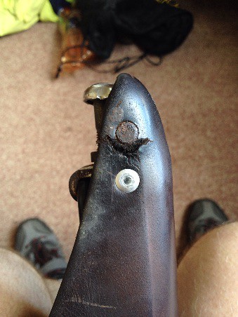
Today Saturday was a small ride from Brighton into town, then in the afternoon - after finding my Brooks leather saddle tearing quite badly I set about finding a place I could add a rivet to help prevent it getting worse too quickly. (In Brooks defense it did sit out in all weather 24x7 for 18 months then get ignored for 10 years).  I really didn't want to ride around town here for this the Waitangi long weekend without some form of repair.  At this point I'll paste the content of an email that explains the story.

NZ fire service to the rescue...
My beloved Brooks leather saddle - (used by all serious tourers) has begun to tear only a few days into the trip. Left as it was it would have continued to tear rapidly. Immediately behind the tear, a piece of plate (part of the leather tensioning mechanism), so I tried a few places to see if they had a drill press and pop rivet gun but to no avail. 2 bike shops in town had a drill press but were closing now. I set off in the direction of both Mitre 10 and Bunnings for riveting gear both open til 6 - only to find an open Supercheap Auto on the way. Buying the cheapest rivet gun I could, a pack of 100 rivets and a 5mm drill I asked about any drill press out the back, but no. (Only the one on display). I then set about wandering the city streets at 5:45 on the Saturday evening of a long weekend looking for any businesses remotely mechanical that might have a workshop with drill press. The railways yes but not here at the station. At Cadbury I couldn't see anybody through any of the locked gates or doors. Several closed panel beaters. Then magic, on the other side of the intersection a fire station.  Fire Stations , most of the time full of guys looking for a diversion, and they'd have to have a workshop out back. Now, how to get their attention (no, not like that). Looking through the front glass vehicle doors I saw a few guys and kept knocking until I got a response. Holding up a 5mm drill bit and a bike seat and miming the action of using a drill press through the glass he nodded, opened the door and introduced me to Jeff. (It was good to resurrect the mime skills so use ful on an international bike trip. )
Seat repairs
Jeff the fireman also went out of his way to dig out their riveter and rivets figuring I could take the unopened items back for a refund.  I used their riveter but needed my rivets so that next time NZ fire Service Dunedin want 4.8 x 9.5 pop rivets they'll have a pack of about 92 (I've re-enforced both sides of my seat and hung onto 6 rivers and the 5mm drill just in case)
My first meat meal in a while tonight Shish Kabab from a Dunedin Turkish shop with Ayran that wasn't on the menu but they made for me. (If you're going to eat Turkish...)

Tuesday, September 2, 2008

Home in Melbourne after 17 months and 30,000km

Well,  I guess that's it... Melbourne...  Back to the real world...
It's just about over, just a short ride to home today -o- Melbourne from the south side of the Yarra River
I arrived into Melbourne on Saturday 30th August, and home to the eastern suburbs on the Sunday 31st, after delaying my arrival with a few days in numerous places along the south coast of mainland Aus.  (I needed to delay my arrival until the tenant would be out of my house.  I gave notice when I got to Darwin, but I guess I should have done it from East Timor or Indonesia.)
It's quite a long time since I've had cold & wet every day, but SA & Vic in winter reminded me what it was like.  (Of course my arrival into winter happens to coincide with the best snowfalls for many years.  Great for the ski resorts and skiers - not quite so ideal for cyclists.)
What lies ahead now is painting the house (before I empty all the furniture out of the self storage unit into it), job hunting, moving in, organising the house the framing of many paintings and other artworks/craftworks I purchased along the route and mailed home.  I shudder to think of how long it'll take to finish organising the thousands of photos I've taken - and wonder if I ever will?
Yesterday I spent much of the day on the phone at my parents house arranging power, gas, phone and other services for the house, and such mundane but real life things like as Ambulance membership, Curriculum Vitae, and beginning to get together the items I need to fix up the house.   My heart sank when I saw that several water leaks in the roof would mean that I couldn't paint as I'd planned.  I've decided though that I'll paint anyway and the water affected places will get patched up after the leaks are fixed and the weather has warmed enough to dry out the plaster sufficiently.
After only one day of no riding. This morning it hit me & I felt I needed to get up early for a ride.   I've delayed it now to write this, as the water once again falls from the sky outside. 
The trip from Adelaide to Melbourne:
When I left Adelaide, I knew I had to take my time or I'd be home too early to get into the house so I decided to head to Kangaroo Island and fill in a week travelling to and sightseeing around the Island.  I headed out to the Adelaide beach side suburb of Glenelg then followed the coast toward Kangaroo Island (K.I.) and home.  The weather - as I eluded to above - has not been ideal cycling weather and as I got closer to Cape Jervis and the K.I. ferry I learnt more about what it was going to cost me to go to K.I.  From what I'd read "free camping" on K.I. would not be so easy so combined with the expensive ferry, I decided to forgo K.I. and go there some other time when the money wouldn't be wasted on a trip in such lousy weather.  It meant that I'd need to fill in time elsewhere but my plans of a grand entrance to Melbourne had slowly been fading anyway.  With a tenant still in the house, a weekend arrival with an open house / welcome home / house warming wasn't going to be possible unless I delayed even longer.  For extending the trip Mum came to the rescue with contacts and accommodation available in both Warrnambool and Apollo Bay, I also arranged some warm & dry accommodation in other places through the touring cyclist hosting website warmshowers.org
Strathalbyn S.A. - very pretty little town. These cows were incredible. They ran at least 500m along the roadside paddock fence following me, and didn't stop until forced to by a cross fence at the end of the paddock
-o- Strathalbyn A very pretty little town centre.
-o- Bike chasing cows, they followed me, running as a bunch the entire length of their paddock. 
After passing by Cape Jervis I endured more horrid South Australian wind as I crossed from the Fleurieu Peninsula around Lake Alexandrina and down the coast toward Mount Gambier.  One morning in Kingston S.E. (after riding from 1:00AM to 3:00PM the previous day in order to avoid the wind) I awoke to a tent shaking violently, and giving the impression that a cyclone was in full swing outside.  I lay there in bed and conceded that I wouldn't be going anywhere today.  Robe was only 40km down the road but with a head wind this strong 40km was probably all I'd be able to ride in a full day.  After taking some photos & a video clip inside the tent with it violently reacting to the wind I decided to get up and just have a look outside (after which I would crawl back into bed).  When I stuck my head outside, I was shocked to find that the wind had swung right around and was blowing with this incredible intensity from the North West.  With Robe 40km down a bendy road to the SouSouWest and Mt Gambier 160 km down a straight Princes Hwy due South East, the temptation to leave the coast to get a gale force tail wind for a day was just too great.  With the wind immediately behind me as I sailed down the Princes Highway, I made the 108km to Millicent in record time.  Millicent to Mt Gambier wasn't quite so good as the road was well protected by Pine plantations and the rain really set-in for the first time.
 
The wind was howling this morning.  The tent was thrusting from side to side like there was a Cyclone outside. (Kingston S.E. South Australia) Inside the backpackers Jail
-o- It felt like a cyclone was in full swing
-o- "The Old Jail"  (H.M. Backpackers prison Mt Gambier )
As always seems to happen when you are on a bike, the day I stayed in Mt Gambier the wind would have been behind me if I had continued on toward Victoria instead of taking the day to look around town.  I left the following day into not only a strong head wind, but also head on rain and hail as I headed to the Victorian Border and toward Portland.
As I mentioned above I filled in a bit of time staying in Warrnambool for two nights then after one more camp near Princetown had four more comfy nights in Apollo Bay.   The trip from Princetown to Apollo Bay was a bit more hilly than I'd expected.  I haven't been there for a long time and I was expecting hills near Cape Otway, but didn't expect to start climbing real hills so many km's before Lavers Hill (I guess that's why they called it Lavers Hill )  I ran into more touring cyclists on this leg, one from Austria who said he was a bit surprised that Australia actually had hills and wasn't all flat.  The other cyclist a Kiwi from Nelson approached as I was watching a koala moving between trees. Good timing meant that the Koala was on the ground changing trees as I rode past - you never tend to see them if they are just sitting up in the canopy eating.  Apollo Bay was a good introduction to normal life again.  Cooking with more than just one billy, cooking a more varied diet, listening to radio, watching some TV, even mowing lawns - then of course cleaning before I left.  The only cleaning my tent would get was the daily sweep out with the bare hand each morning as I prepared to roll it up.
Once I got a little north of Lorne I was in familiar territory, riding roads that I've seen many times in my life.  Now it just seemed like I was riding, Lorne to Torquay, Geelong and up the Geelong Rd to Melbourne.  It certainly didn't feel like the same trip as Paris, Brussels & Prague, or riding through Eastern Turkey to cross the border into Iran or Trekking in Nepal all those months ago.  The highlight of the day was on the Geelong Road when the Cycle computer clicked over to 30,000km.
more Gt Ocean Rd views The 12 Apostles (which now has a very fancy visitors centre, fancy pedestrian underpass and viewing platforms)
30,000km reached on the Geelong Rd fury friend - near Apollo Bay
-o- The Great Ocean Road view
-o- The 12 Apostles the bike & I 
-o- 30,000km and smiling (The Geelong Rd)
-o- Cute but the toy shop ones are cuddlier (Koala near Apollo Bay)
Once in Melbourne I made my way to Burnley where I camped beside the river.  It somehow seemed fitting that the last night before I got home should be a bush camp somewhere in the middle of an inner suburban area of my home town.  For all the Melbournians reading this, the camp was in Loy's paddock.  That's the bit of bush between the inbound Burnley on-ramp (tunnel approach) and the river.  It's not quite as deserted as it once was, with the cycle path going through at a high level above the river, but there's a lovely bushy bit down the hill to the river flats.  And that bushy bit has some ideal small tent sites in it.  Next time you are on the cycle track check it out.
The early morning river shot was meant to have blue sunny sky.   Maybe next time I ride 1/2 way around the world? 
-o-  Melbourne
I wanted early morning shots of the bike and the city but I didn't get the lovely Blue Sky morning that I wanted.  I headed back along the river for the photos anyway before passing through the city and heading east on the Yarra main trail, Koonung Creek & Mullum Mullum Creek bike paths.  I remember a time not too long ago when I thought riding from Ringwood to central Melbourne was a long way, but today it felt like nothing.  I had so much time to do it that I used the time to drop in on various friends that lived close to the bike path.  With the opening of a new section of bike path alongside the new Eastlink Tollway it's now possible to ride from the city to within about 1km of my home (about 40km - via the path) without needing to ride on or even cross a road. (actually there is one - but only one - crossing, Bulleen Rd).  With all the stops along the way I used the whole day to do that short distance and didn't actually get to the house until it was dark.  I couldn't stay in the house that night as although the tenant drove the truck out of the driveway while I was there looking at it, the tenancy wasn't going to be officially over until the next day.
Now the house is empty, I've fixed one leak in the roof, I still have a couple to go before I start slapping on the paint that I bought today.   I passed by the self storage unit today and confirmed to myself that there is no way I'll be getting things out of boxes until the house is ready for all the furniture.  My best friend David and I packed the self storage in the same way that we used to pack audio gear into the back of our "JDE Audio" truck.  There is very little "air" in my storage space.  We were always good at high density packing and that's just what we did in the self store.

I'm now back in the real world, house repairs, gardening, bills, job hunting and eventually I'm hoping to get around to sorting out souvenirs and photos from the trip.
Jeff

Thursday, August 14, 2008

Adelaide, and feeling very close to home

I've made it down the Stuart Highway - and done a week long detour into Uluru (Ayers Rock) Kata Tjuta (The Olgas) and Watarrka (Kings Canyon).  It wasn't quite as bad as I thought it might be (knowing that the prevailing winds would be Sou-Easters.  I had some really shocking days, really demoralising ones when you struggle like crazy and make very little distance.  On these days you can't hear anything but the wind buffeting in your ears and you really wish it was over.  But then there are other days when it isn't quite so bad.  In fact I had one incredible day after I'd visited Kings Canyon.  I set a new record for my longest day - one that I am sure will last for the rest of my days.  235km in a one day, with a heavy touring bike!!!!!  I was impressed.  But I can't take all the credit though, the wind was blowing my way that day.  As they say "Make hay while the sun shines" -  I just kept riding until it got dark - and then some.  From Kings Creek Station all the way to Erldunda and back to the Stuart Highway.
A cold night. All my bottles froze - including the 5 litre one. 
Some mornings got a little cold - both these bottles were frozen.
Uluru - as seen from a dune near Yulara (Ayer's Rock Resort)  Kata Tjuta - as seen from the same dune near Yulara (Ayer's Rock Resort) footprints in the dunes - Lasseter Hwy N.T.
The bike and Uluru
Me and Kata Tjuta
(Lizard) Footprints in the roadside dunes
Dust Storm near Mt Ebenezer.  Lasseter Hwy N.T Everybody warned me about these road trains but if the wind is from the S/E they are no problem at all.  If they pass on the windward side though (wind from S/W) it's another story - They are heaps better than many other trucks on the road with over-size loads though (If you look hard my bike is leaning against it - for size comparison) Camped for the night at the border rest area I had a lovely stew dinner courtesy of some of the Grey Nomads.  (Mrs. in red & white stripe shirt, Mr in the green tartan. - Sorry Guys I've forgotten all your names & didnt record them) 
Dust storm near Mt Ebenezer (N.T.)
My bike leaning against a road train (some have one more trailer than this)
Grey Nomads - as we love to call them.  This lot at the S.A/N.T. border roadside stop.  More free stew. Yum!
From Uluru and surrounds it was down into South Australia and what I really imagined the outback to be like.  Northern Territory had been a bit of a surprise for me.  I had imagined that N.T. too would have lots of nothing, but the nothingness is really all claimed by South Australia.
Around Coober Pedy lots of nothing, then a small break and a little bit of scrub around Glendambo before heading back into the nothingness of Pimba & Woomera.
The approach to Coober Pedy QF-JJ Ready for take off.  This section of road doubles as a landing strip for the Royal Flying Doctor Service. Camping off the side of the road near Glendambo S.A.
Coober Pedy mine tailings
RFDS landing strip - A.K.A. The Stuart Highway
A roadside camp near Glendambo (a region of scrub in the middle of a huge nothing)
I was expecting a lot less of Port Augusta than what I saw.  Port Augusta town centre is actually a very pretty little place, but the day I left there I rode all day and didn't even make it to the place I planned to have lunch.  The road has the southern Flinders Ranges running along the eastern side and they just tunneled the wind straight into my face.  Add this to delays when taking 20 to 30 minutes shelter avoiding the rain every few hours and it wasn't a very fulfilling day.
I left the highway at Port Pirie, to go into the town centre and collect a spare tyre and get yet another patch on the tooth I had previously had patched in Brussels and Bangkok. (Hopefully this patch really will last until Melbourne when I can get it fixed properly).   Heading south from Port Pirie I was on minor roads with a very green and pretty roadside to Port Wakefield before heading down into Adelaide.
Who said there was nothing to look at when riding in northern S.A. ??? Port Broughton. S.A. 
Lots of nothing near Woomera
Down further south the very picturesque Port Broughton
40km north of Adelaide is a little place called "Two Wells".  They have a very helpful information centre where I picked up info on where the backpacker's budget accommodation was in Adelaide plus info on Kangaroo Island and the roads to Melbourne.  One of the ladies there just couldn't believe that I was going to ride from Two Wells... "...all the way to Adelaide."  (all 40km of it).  Her co-worker tried to tell her that it really wasn't far compared to where I'd been !!!!!!!   It left a smile on my face and it still does when I think of it.
Into Adelaide, the river Torrens and the Festival Centre.  An Adelaide Icon.
Adelaide, the river Torrens and the Adelaide Festival Centre.
From here I think I'll now head south to kangaroo Island to fill in a bit of time.  If I headed straight to Melbourne now I'd arrive before the tenant vacated my house.